GEOGRAPHIC RESEARCH - The Natural Environment of Tongariro National Park
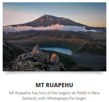
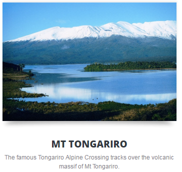
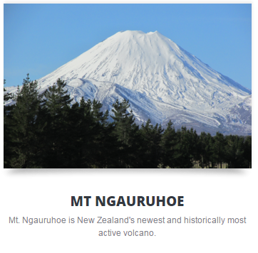
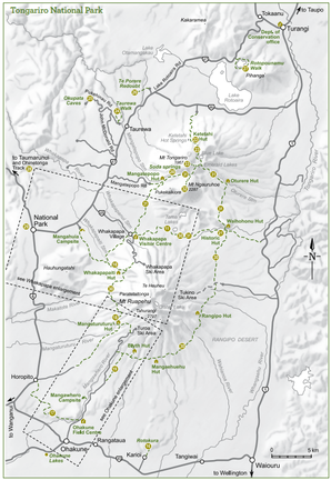
National Park Village borders the dual World Heritage Tongariro National Park (Tongariro Crossing) to the east and the Whanganui National Park to the West, in the middle of a true wilderness wonderland. The Village is located near the base of Mt Ruapehu, at the intersection of SH4 & SH47 on the volcanic plateau, half way between Auckland and Wellington. It boasts great views of all three mountains, Mt Tongariro, Mt Ngauruhoe (Mt Doom in the Lord of the Rings filiming locations) and Mt Ruapehu - a unique dual world heritage area, 300,000 years in the making.
The 3 Mighty Mountains
|
|
|
PROCESSES THAT FORMED TONGARIRO NATIONAL PARK
TECTONIC PROCESSES
50 Million Years Ago
New Zealand was once part of the sea floor, and was connected to Australia. Over time sand and silt eroded down the Gondwana land mass. This compacted and formed a sedimentary rock called graywacke.
50 Million Years Ago
New Zealand was once part of the sea floor, and was connected to Australia. Over time sand and silt eroded down the Gondwana land mass. This compacted and formed a sedimentary rock called graywacke.
|
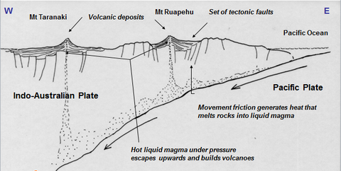
2 Million Years Ago The Pacific plate subducted under the Australian plate and volcanism began. This process resulted in magma forming 150km below the Tongariro Volcanic Centre. |
250,000 Years Ago
Ruapehu was formed. There were 4 different cones over different times. The original cone was called Te Herenga, and has now mostly eroded away.
20,000 Years Ago
A lot of volcanic activity occurred from the vents of Tongariro and Proto-Ngauruhoe (a cone that existed where Ngauruhoe is today.)
|
GLACIATION PROCESSES
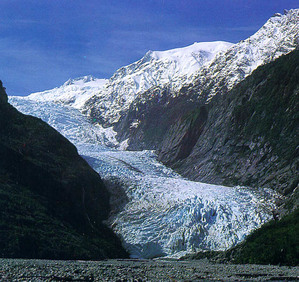
20,000 years ago, New Zealand was going through its last Ice Age. Permanent snow covered the peaks to 1500m. Snow accumulated in the valleys and glaciers were formed. Some glaciers were up to 5km long. Glaciers cut into the volcanic ash, carving out U-shaped valleys e.g. Mangatepopo Valley. They also wore down the height of the old volcanoes (Proto-Ngauruhoe) and harder erosion resistant rock was left behind. |
|
CLIMATIC PROCESSES
Climate refers to the average weather conditions in an area over a long period of time. The general pattern of climate in the Tongariro Volcanic Centre is varied depending on the altitude and the direction of the slope.
Altitude
Relief affects climate through altitude.
Air cools as it rises so at higher altitudes, air is colder.
This has implications for plant growth and soil temperatures.
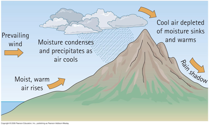
Relief
Relief also affects the climate through orographic effects. When prevailing westerly winds and north-westerly winds are forced to rise over the volcanoes, rainfall on the western and north-western slopes occurs. On the leeward side of Ruapehu, Waiouru receives 62% less rain than the Chateau.
Climate refers to the average weather conditions in an area over a long period of time. The general pattern of climate in the Tongariro Volcanic Centre is varied depending on the altitude and the direction of the slope.
Altitude
Relief affects climate through altitude.
Air cools as it rises so at higher altitudes, air is colder.
This has implications for plant growth and soil temperatures.
Relief
Relief also affects the climate through orographic effects. When prevailing westerly winds and north-westerly winds are forced to rise over the volcanoes, rainfall on the western and north-western slopes occurs. On the leeward side of Ruapehu, Waiouru receives 62% less rain than the Chateau.
|
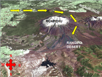
Wind funnelling occurs where air is channeled through the Tama Saddle (the area of land between Ruapehu and Ngauruhoe). The wind changes direction and blows around the base of the mountain. Wind speed is increased. As the north-westerly winds gather speed, they have a significant impact on the Rangipo Desert. Drying winds are a major factor in creating the desert-like environment. The rainfall is low (1048mm to 1548mm per year). |
|
|
VEGETATION
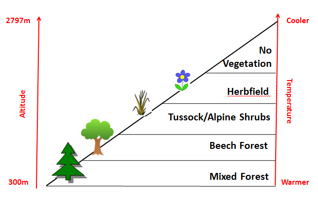
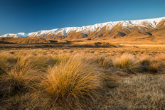
The Tongariro Volcanic Centre shows a distinct pattern of vegetation. The predominant vegetation at lower slopes (up to 1250m) on the east and west sides of the region is tussock grassland. At higher altitudes there are sparse alpine species. |
|
|
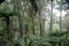
Podocarp Forest
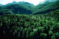
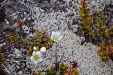
Podocarp trees form the canopy of the forest. It is shaggy and uneven bush found around Ohakune and on the slopes of Pihanga, Hauhungatahi and Kakaramea. The major podocarp trees are Rimu, Kahikatea, Matai and Miro. Podocarp forests grow to an altitude of 1000m Beech Forest Beech forest grows in altitudes of 950m to 1530m. There are a variety of beech trees (mountain beech, red beech, silver beech). A large Beech forest on the Southern slopes of Ruapehu were sheltered from the devastating Taupo eruption in 183AD. Tussock Tussock is a grass like type of vegetation which is superbly adapted to surviving in cold temperatures and winds of high altitudes. On the slopes of mountains where fire and eruptions have prevented the regrowth of forest, tussock grows. Herb field Above 1500 m, the terrain consists of gravel and stone fields and is accordingly unstable. Nevertheless, some plants occasionally settle there, such as curled leaved neinei, snow totara Above 2200 m live only crustose lichens. |
|
THE EFFECT OF VOLCANIC ERUPTIONS ON VEGETATION
One of the major processes determining the pattern of vegetation is volcanic activity. This impact is both direct (through eruptions) and indirect (through the high alpine landforms produced by volcanic eruptions).
The Taupo eruption of 186AD had a significant impact on the vegetation of this area. The eruption destroyed most of the beech forest, as far south as Waiouru either by the blast or by the burning. The charred remains of the forests were buried under layers of white pumice.
Since the Taupo eruption the vegetation in the Tongariro Volcanic Centre has regenerated slowly. However, on the eastern and northern sides of Mt. Ruapehu the regeneration process is particularly slow due to lahar activity and stream deposition on the Rangipo Desert combined with volcanic ash-falls, falling most frequently here with prevailing south-westerly winds.
The southern sides of Pihanga, Hauhungatahi and Ruapehu were sheltered from the hot pyroclastic flow. Consequently these are the only parts of the Tongariro Volcanic Centre which have fully developed into mature native forest.
ASPECTS OF THE MOUNTAINS
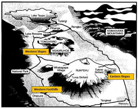
Eastern Slopes
The Rangipo Desert receives 1000 - 2000 mm of rainfall per year, but resembles a desert because of poor soil quality and drying winds.
Landforms - This is an area of gentle slopes. There is evidence of ash deposits from when Ruapehu has erupted in the past and thick deposits of ignimbrite from the Taupo eruption.
WHY is this area so prone to ash deposits? - Prevailing westerly winds carry ash from eruptions to the Rangipo Desert.
WHY is this area prone to wind erosion? - The strong prevailing winds that come down from the Tama Saddle, and a lack of vegetation.
Vegetation - Tussock is a grass which has adapted to surviving in cold temperatures and winds of high altitudes. On the slopes of mountains where eruptions have prevented the regrowth of forest, tussock grows.
Soil - The Rangipo desert has very poor soils. The topsoil is often blown away by the wind. The lack of rain and stong wind means the soil hardens and plants struggle to grow.
Western Slopes
Between 1200 – 2000 metres above sea level
Landforms - The Mangatepopo Valley was carved out by the Mangatepopo Glacier – it is a U shaped valley. Moraines (glacial debris) line the valley (lateral moraines) from 14,000 years ago. The floor of the Mangetepopo Valley is gradually being covered with andesitic lava flows from Mt Ngauruhoe.
Pukekaikiore was active 190,000 – 120,000 years ago. It was eroded and modified in the Ice Age by glaciers. It is on the southern side of the Mangatepopo Valley.
Pukeonake, a scoria cone, is 5.6km west of Ngauruhoe. It is over 23000 years old. Stream erosion and the draining of a crater lake has cut a steep gully inside the cone and the south west wall. It is possible that glaciers also eroded away material.
Soil - Soils are very thin and lack basic nutrients. Because of the heavy rainfall due to orographic rainfall (3000mm per year), leaching occurs. This removes the nutrients. Soils are also thin due to steep slopes and the cold climate which makes breakdown of rock and vegetation slow. LEACHING - Loss of nutrients caused by the draining of water through the soil.
Vegetation - Because of volcanism, ice and water erosion is constantly modifying the land surface which makes it difficult for plants to survive.
Western Foothills
Area to the west of the mountains and the area on the southern slopes of Ruapehu 1200m and below
Landscape - This is an area of gentle slopes. Material is deposited here by glaciers in the ice age. It is also and area of deposition from volcanic eruptions (ash and lava flows).
Valleys have been carved out by rivers. The area also has moraines created by glaciers that flowed down slope of Ruapehu. Over time water has also carved out valleys and waterfalls over old lava flows.
Vegetation - This is an area of shrubland, swamps, Beech forest and Podocarp forest.
The climate, relief and soils here are suitable to support trees. Trees need soils that are moderately deep and the flatter slopes of this area allow this. Podocarp forests extend up to 1000m above sea level – rimu, kahikatea, matai, miro. Beech Forest exists 1000-1200m above sea level.
Soil - This area has deep soil called yellow-brown pumice soils. It is sandy, free-draining soils that easily erodes if the surface vegetation and thin topsoil are removed. Soils are affected by numerous eruptions making them immature. Eruptions also upset the pH of the soil making them acidic.
EXTRA INFORMATION
|
This is a Pdf of the PowerPoint we went over in class. Reread it to see if there was any information that you missed
| ||
THE ASSESSMENT
| 91430_tongarironationalpark_assessment.pdf |
|
| ||||

|
Here is a list of Apps that you can use in the field trip. Test them first and see if you need access to data to be able to use them. |
ROOM ALLOCATION
Please complete the form below
Please complete the form below
HOW TO COMPLETE FIELD RESEARCH
