GLOBAL STUDY OF DESERTIFICATION
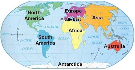
GLOBAL
This means you need to be aware of the different regions of the world. You need to refer to different regions of the world. Talking about Central African countries only is NOT global. Double check what GLOBAL means in the key terms at the bottom of this page.
This means you need to be aware of the different regions of the world. You need to refer to different regions of the world. Talking about Central African countries only is NOT global. Double check what GLOBAL means in the key terms at the bottom of this page.
DESERTIFICATION
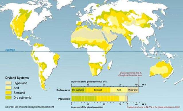
Desertification occurs where land is turned into desert. It is the drying up of previously fertile land.
It occurs mainly in semi-arid land which border the world’s major deserts
(Semi arid – areas of low/no rainfall) - the map below shows the semi-arid areas of the world.
Desertification turns productive land into non-productive desert. It occurs mainly in the semi-arid areas that border deserts. 12 million hectares of land becomes useless for cultivation each year due to desertification.
More than 110 countries have drylands potentially at risk from desertification which could affect 900 million people. Desertification already affects Africa, China, Australia and North America.
(REMEMBER: This is about Desertification NOT Deserts)
The Pattern of Desertification
When you look at a pattern you need to think about the following things:
•Is there an area that is denser, with objects than others?
•Is there an area that has fewer or no objects than others?
•Are there clusters of objects?
•Is there a randomness or uniformity to the location of the objects?
•Does there seem to be a relationship between individual objects (is one object located where it is because of another)?
(in this case ‘objects’ means areas of desertification NOT deserts)
Examples of terminology to describe spatial patterns include: concentrated, random, linear, sparse, clustered, dispersed, peripheral etc. You need to be able to explain the pattern using one or more of these words.
What causes Desertification?
Desertification is caused by some Natural and Cultural factors.
Natural factors:
1. Droughts
2. High temperatures causing lack of moisture in the air
3. Infrequent and intense periods of rainfall
Cultural Factors:
1.Overgrazing
2.Over-cultivation
3.Deforestation and excessive fuel wood cutting
4. Inappropriate irrigation practices.
Natural factors:
1. Droughts
2. High temperatures causing lack of moisture in the air
3. Infrequent and intense periods of rainfall
Cultural Factors:
1.Overgrazing
2.Over-cultivation
3.Deforestation and excessive fuel wood cutting
4. Inappropriate irrigation practices.
| fact_sheet_desertification_causes.pdf |
Social and Economic Significance of Desertification on People
Desertification has a huge impact on people - socially and economically.
There are lots of examples you looked at in class from around the world such as Turkey, Australia, Aral Sea, China, Jordan, the Sahel etc. Recap your knowledge by looking at the video clips below.
There are lots of examples you looked at in class from around the world such as Turkey, Australia, Aral Sea, China, Jordan, the Sahel etc. Recap your knowledge by looking at the video clips below.
|
|
|
|
|
|
|
|
|
|
|
|
|
|
The information you watched on CHINA is in 3 parts (see below):
|
|
|
Examples of Desertification
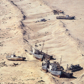
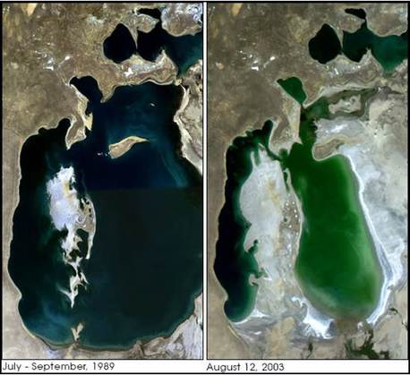
Example #1: The Aral Sea
Location - Between Kazakhstan and Uzbekistan
What it has to do with desertification - It was once the 4th largest lake in the world. The Aral Sea has decreased to half of it’s size. The area where the Sea used to be, has turned to desert.
Location - Between Kazakhstan and Uzbekistan
What it has to do with desertification - It was once the 4th largest lake in the world. The Aral Sea has decreased to half of it’s size. The area where the Sea used to be, has turned to desert.
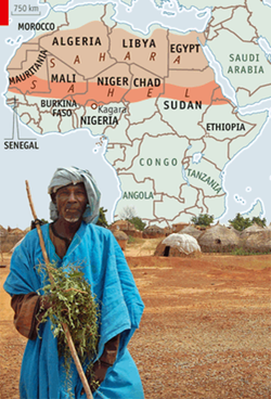
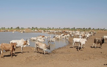
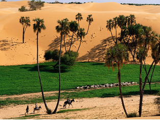
Example #2: The Sahel
Location - in Northern Africa (as you can see in the image to the left)
What it has to do with desertification - it borders the Sahara Desert and overgrazing is turning land into unusable desert. Around 50 million people live in the Sahel.
There is more information about the Sahel on the sheets you read in class. You can download a copy of it below.
| fact_sheet_sahel-environmental_issues.pdf |
The Assessment
KEY TERMS:
Geographic topic – refers to a natural and/or cultural study that has a global spatial dimension.
Global scale – refers to regions and nations across different continents or hemispheres. (you can not just talk about places in the same region)
Pattern – repetition of phenomena (features or happenings) that are interrelated and form recognisable characteristics over space (spatial) and/or time (temporal) (SPATIAL patterns include: concentrated, random, linear, sparse, clustered, dispersed, peripheral )
Factor – relates to why the pattern occurs
Analyse – examine and explain the component parts of, and their relationships, to determine the geographic nature of a topic at a global scale.
In detail – covering more than one aspect in-depth or a number of aspects adequately.
Comprehensively – covering a broad range of aspects in-depth, using many detailed examples
| 91432_assessment_for_2016.pdf |
| resource_booklet.pdf |
